When a traveller visits an unfamiliar location, it is useful to have some sort of information service to provide background about the location. A very effective information service is the human tour guide, who provides some organized overview of a area, but is often able to answer spontaneous questions outside of the prepared overview. The Cyberguide project was an attempt to replicate this human tour guide service through use of mobile and hand-held technology and ubiquitous positioning and communication services [3, 14, 13]. Over the course of two years, we built a suite of tour guide systems for various indoor and outdoor needs within and around the Georgia Tech campus. One example supports a community of users in pursuit of refreshment at neighborhood establishments around the Georgia Tech campus. This prototype, called CyBARguide, used a Newton MessagePad and a GPS receiver to cover approximately 12 square miles of midtown Atlanta, using multiple maps at varying levels of detail. The interface on the Newton is shown in Figures 3 and 4. Users driving around Atlanta can find out the location of establishments that satisfy certain requirements (special offers, free parking, good ambience). Deciding on a particular location results in an interactive map that provides directions to the establishment. In addition, after visiting an establishment, the user can leave comments that are then available to future users.
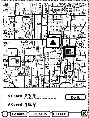
Figure 3: The interactive map of the CyBARguide prototype indicating the user's location (the triangle) and the location of
establishments previously visited (the beer mugs).
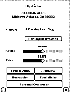
Figure 4: CyBARguide's user-modifiable database supports the
long-term collection of group comments for a location.
The various Cyberguide prototypes varied over whether they supported indoor or outdoor (or mixed) tours and whether they provided support for individuals or groups (synchronous and asynchronous). Positioning information was used to inform the interface where the user was located. That information could then be used to provide information automatically about the surrounding environment. Different modes of interaction were also made possible, ranging from hand-held, pen-based interactive books to hands-free interaction with heads-up displays or audio-only interfaces. Positioning information ranged from commercially available services, such as GPS, or home-grown beacon systems for indoor use. The history of where a tourist had travelled over time was used to provide an automated compilation of a travel diary and to make suggestions on places of interest to visit based on past preferences. Communication was provided either through an asynchronous docking metaphor or wireless/cellular connections.
Ultimately, this project was not as successful for ubicomp research as it could have been. Though successive prototypes were similar in functionality, very little was preserved from version to version. User evaluation indicated the need for major modifications and these modifications were not easy to do quickly, so no single prototype experienced extended use. As a proof of concept, Cyberguide was very useful. As a research prototype that allowed for investigation of how ubicomp affects our everyday lives, it was not successful. Unfortunately, too many ubicomp research projects fall into this category.