Home
FACs
More About FACs
The AO
A Shau Valley
• A Shau SF Camp
Hué
• Hué Cit Airfield
• MACV Compound
• LCU Ramp
• Hué Goose
Battle of Hué (Tet 1968)
• Trail FACs
The Missions
Visual Recon
• Sunken Sampan
Close Air Support
• CAS Munitions
• Rules of Engagement
• TACS
• Battle at Hua Cu
Interdiction
• McNamara Line
• Choke Points
Ranch Hand
Trail Dust Mission
Arc Light
SAR
Hammer 51 Rescue
Search for Jolly 23
• Msn Reports
• Search Area Map
• Search Rejoined
• Link to Past
Jungle Penetrator
Legacies
Aircraft
O-2A
Glossary
Resources
Contact
Return to Top
Return to Top
|
| |
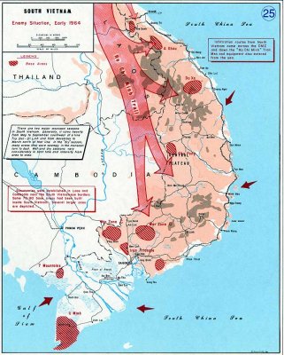
A key part of the U.S. strategy in Southeast Asia was the interdiction of the supply lines to the Viet Cong (VC) and North
Vietnamese Army (NVA) units in South Vietnam.
|
Infiltration routes into South Vietnam.
(From The West Point Atlas of American Wars).
|
These supply routes ran through neighboring Laos and Cambodia and have been collectively referred to as the Ho Chi Minh Trail.
In fact, there was no official "trail."
Rather, it consisted of a series of roads and footpaths of varying condition depending on terrain, weather and level of U.S. interdiction effort.
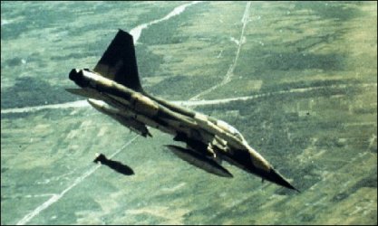
Where possible, the North Vietnamese used trucks to transport supplies.
These trucks became a primary target of the air war over North Vietnam and Laos
(
Operations Rolling Thunder, Steel Tiger and Tiger Hound).
Forward air control functions in the last two of these areas were handled by the
23rd TASS
flying from Nakhon Phanom Royal Thai Air Force Base in Thailand and by the
Covey FACs of the 20th TASS based at Danang and Pleiku.
Additional links on air operations over the Ho Chi Minh Trail:
• The Ho Chi Minh Trail (Air Force magazine)
• Night Operations Over the Trail
• Early history of 23rd TASS operations
Air Force intelligence specialist Jim Gordon has provided an excellent description of interdiction operations over the Ho Chi Minh
Trail (including reconnaissance photos) at his Web site
[click here] .
Some supplies were brought into the western areas of South Vietnam (especially the
A Shau Valley)
by truck, but the last part of this supply chain in the south was conducted by porters using trails cut through the jungle and over the mountains under
difficult conditions.
FACs spent a significant amount of effort looking for signs of movement in these border areas.
The further down the Trail supplies were moved and dispersed, the more difficult it became to locate and destroy them.
Throughout the war, South Vietnam and the United States also used covert forces to monitor and interdict supply opeations along the Ho Chi Minh Trail.
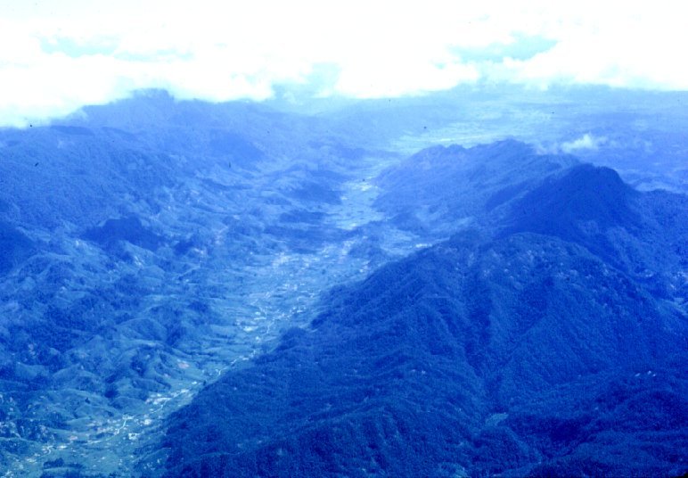
The A Shau Valley was a principle infiltration route into the I Corp (northern) region of South Vietnam.
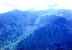
|
A Shau Valley looking south
A Luoi airfield to right of center at top.
Click on image for larger view. |
As such it was a prime visual reconnaissance target for the FACs of Hué.
Constant patrolling enable us to spot changes in the road tracks and locate hidden truck parks.
We kept a list of suspected truck parks and supply areas ("hip pocket targets") to use in case fighters with spare ordnance became
available on short notice while we were doing visual reconnaissance over the Valley.
If we found what we thought was a particularly lucrative target (usually confirmed trucks) we could request an immediate airstrike.
Depending on activity in other parts of the theater, we could get a set of fighters diverted from a lower priority target or ground alert fighters scrambled at our request.
We were equal opportunity users of airpower: USAF, Marines, Navy, VNAF
I even worked an Australian Canberra bomber (similar to our B-57) , callsign Magpie.
We drew infrequent ground fire over the A Shau Valley unless we were putting in an airstrike.
The bad guys knew we could bring down the wrath of Thor on their heads so they tended not to stir things up.
Once the bombs started falling, however, all bets were off, and Charlie made up for lost time in fighting back.
The A Shau Valley was a dangerous place, and a lot of aircraft were lost to ground fire.
(Click here for a narrative of one such loss and the rescue of the crew.)
| |

|
The McNamara Line
Click on image at left for details on the "McNamara Line," the
electronic fence built around South Vietnam to stop the infiltration
of troops and supplies.
|
|
| |

|
Choke Points
Click on image at left for information, photos and maps of the
importance of choke points in the interdiction effort.
|
|
|
|
Visual Reconnaissance
Return to Top
Close Air Support
|