
Home
FACs
More About FACs
The AO
A Shau Valley
Hué
• MACV Compound
• LCU
Ramp
• Hué Goose
Tet 1968
• Trail FACs
The Missions
Visual Recon
• Sunken Sampan
Close Air Support
• Rules of Engagement
• TACS
• Battle at Hua Cu
Interdiction
Ranch Hand
Trail Dust Mission
Arc Light
SAR
Hammer 51 Rescue
Search for Jolly 23
Jungle Penetrator
Legacies
Aircraft
O-2A
Glossary
Resources
Contact
|

| |
| |
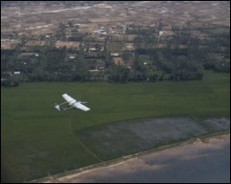
O-2A on a VR mission over Vinh Loc Island,
Thua Thien Province, 1968 (© Tom Pilsch)
|
|
Visual reconnaissance (VR) was a core mission of the forward air
controller in SEA.
Whether serving as the airborne eyes for the ground
maneuver commander, searching for hidden transportation and supply targets
or gathering routine intelligence information, the basic VR process --
look, identify, report -- became the core around which all other missions
revolved.
A primary responsibility of the Trail FACs in northern I Corps
was to provide
information to local military commanders, district and province security
forces, and the theater intelligence system. This required
hours and hours
over the varied terrain of the AO -- coastal lowlands, rivers and
sea coast, rice paddies,
multiple-canopy mountain forest -- looking for changes in the normal
patterns of activity. These variations could include
indications of new or
heavier foot or vehicular traffic, changes in local activity patterns, or
evidence of new construction, digging or attempts at camouflage.
The biggest
challenge in the information gathering process was separating the
unusual from the routine.
| |

|
Click on image at left for a narrative and photos on how a sharp eyed
FAC ruined Charlie's night.
|
|
Close Air Support
Return to Top
Interdiction
|
|
|